Visit Mr. Old Wom Tigley to join us in sky watch Friday


The top picture I took this morning shortly after 7am the sky was amazing.
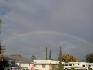
The bottom picture is from yesterday after the rain we finely received, I got this idea from sky watch bloggers. I'm still experimenting.
It look likes we will see more rain today and perhaps some storms(fingers crossed)
I'm am off today so I can do a little chasing if the situation arises. This is what NOAA has to say: THUNDERSTORM IMPACT...
AMPLE MOISTURE CONTINUES TODAY AS A STALLED FRONTAL BOUNDARY LIES
NORTH OF THE STATE. UPPER LEVEL ENERGY IS EXPECTED TO MOVE ACROSS
NORTH FLORIDA...COMBINING WITH THE MOISTURE AND THE FRONT TO
SPARK OFF NUMEROUS SHOWERS AND SCATTERED STORMS...MAINLY OVER THE
NATURE COAST COUNTIES. ADDITIONAL STORMS ARE POSSIBLE OVER CENTRAL
FLORIDA...WITH THE BEST CHANCES OVER THE INTERIOR THIS AFTERNOON.
WITH TODAY`S STORMS...EXPECT BRIEF GUSTY WINDS...POSSIBLY UP TO 40
TO 50 MPH IN THE STRONGER STORMS IN THE NATURE COAST...FREQUENT
CLOUD TO GROUND LIGHTNING...AS WELL AS HEAVY RAINS.
I took this last picture for a friend Ms. Chickadew this one is for you. I never had a flower turn out so well in a photograph.

Happy Friday everyone!!! Have a great weekend!
Jess
CloudStalker

.jpg)
.jpg)
.jpg)
.jpg)

 alt=""id="BLOGGER_PHOTO_ID_5202484107284822082" />


.jpg)


