GULF OF MEXICO...
THE MAIN WEATHER FEATURE ACROSS THE GULF OF MEXICO IS TROPICAL
DEPRESSION THIRTEEN LOCATED IN THE SW PORTION. A TROPICAL STORM
WATCH REMAINS IN EFFECT FOR THE COAST OF MEXICO FROM PALMA SOLA
TO LA CRUZ. SEE SPECIAL FEATURES ABOVE FOR DETAILS. THE SFC LOW
S OF KEY WEST YESTERDAY HAS WEAKENED...AND A NEW LOW MAY BE
FORMING OFFSHORE CENTRAL FLORIDA IN THE WRN ATLC. SEE THAT
SECTION BELOW FOR DETAILS. DRIER AIR IS FILTERING INTO THE E
GULF IN WAKE OF THE DEEP LAYER TROUGHING OVER THE FLORIDA
PENINSULA. IN FACT...BESIDES FOR T.D. 13 OVER THE FAR SW
PORTION...THE GULF IS PRETTY TRANQUIL THIS MORNING WITH A WEAK
SFC PRES GRADIENT N OF 23N AND ABUNDANT NLY FLOW ALOFT BETWEEN
RIDGING BUILDING INTO THE WRN PORTION AND THE TROUGHING OVER
FLORIDA. WILLIS
Now Karen is weakening also, due to shearing ahead of a trough.
I don't think we are going to see any tropical action in Florida(west coast) this year. south florida is getting all the rain action( go Jeff )
I am only in the beginning stages of learning so i shouldn't be to upset i don't even know how to track em yet, but still every since I got back from the plains I have been dting(wanting some mother nature action)
We received heavy rain yesterday for about fifteen minutes .60", no lightning just rain and it was inconvenient rain just as i was about to pick up my son from the buss stop the sky opened up and whoosh.
Now dry air is settleing in and all hopes to a great storm gone....for now.
so darn it, its looks like a nice day today highs in the lower 90's perfect beach day. If you like that sort of thing. So have a great day even though its not gonna storm and pray for Jesse that she(I) gets her storm sometime...
KEEP YOR EYES TO THE SKY JESS...
Thursday, September 27, 2007
Friday, September 21, 2007
93L/still trying
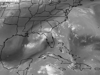
Well so far Port Richey has received 1.42" at my house yesterday.
Worse case scenario= I'm at a friends house without my camera and what happens a beautiful shelf cloud moves in. No camera no picture.
At least we got rain, minor street flooding but that is all. (93l is moving north/northwest heading towards the panhandle, Louisiana area look out dew its coming your way(LOL)!!!for better forecasting on this event i would click on a link to your right(Jeff gammon's and Jenn again are doing a great job!
I had a couple of chase ops yesterday but with out proper knowledge and gear my chase stays close to home, as much as would love to chase patience is my new first name.
there is a 2% chance of tornadoes up in the panhandle today....sigh
I don't know how much more rain we will see from 93 here as the severe storms are off to the west(gulf waters) Its forecast to be a wet afternoon but watching the satellite views it looks like it will be all to the north..i guess we will see.I was right yesterday as i told my predictions to my friends( which is cool because who wants to look like an ass to their friends...lol
I'm too get my son ready for school, Have a great weekend and remember....
KEEP THOSE EYES TO THE SKY.....JESS
update: after further study my prediction is we will see no more rain from 93 but with the east coast seabreeze and the heating of the day we have good chance of storms this afternoon
Wednesday, September 19, 2007
...SPECIAL FEATURE...
...SPECIAL FEATURE...
A WEAK SURFACE LOW PRESSURE AREA AND A UPPER-LEVEL LOW NEAR THE
FLORIDA PENINSULA ARE PRODUCING A LARGE AREA OF DISTURBED
WEATHER OVER THE WESTERN ATLANTIC...NORTHERN BAHAMAS...AND THE
EAST COAST OF FLORIDA. THERE ARE NO SIGNS OF ORGANIZATION AT
THIS TIME. HOWEVER...SURFACE PRESSURES ARE SLOWLY FALLING AND
ENVIRONMENTAL CONDITIONS APPEAR FAVORABLE FOR A SUBTROPICAL OR A
TROPICAL CYCLONE TO FORM OVER THE NEXT DAY OR TWO...AS THE
DISTURBANCE MOVES WESTWARD OVER FLORIDA AND INTO THE GULF OF
MEXICO. REGARDLESS OF DEVELOPMENT...THIS SYSTEM WILL LIKELY
BRING SHOWERS...SQUALLS...AND LOCALLY HEAVY RAINS OVER PORTION
OF FLORIDA DURING THE NEXT DAY OR TWO. MOSAIC DOPPLER RADAR FROM
THE SE US SHOWS SCATTERED TO NUMEROUS SHOWERS WITH EMBEDDED
TSTMS ROTATING CYCLONICALLY MAINLY OVER NORTH-CENTRAL FLORIDA.
SCATTERED SHOWERS ARE ALONG SOUTH FLORIDA EAST COAST.
Wednesday, today Happy hump day its all down hill now.
The skies have been beautiful this week now i have a special interest 93l east of my state and its looks to go right over my area to find his strength in the gulf.
Weather is so complex, I think that's what i like about it so much .its like cooking you need just the right ingredients to make it all come together. the Low pressure is practically sitting right on top of my area and the tropical wave is off the east coast as the low pushes away it will bring the wave and once its in the gulf its anyone's ballgame. so will this be Tropical or sub tropical ether way it will be a learning lesson for me and fun to watch plus the cloud action should be amazing!
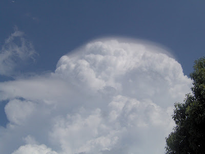
I chose some of my favorite pictures of the sky i took this week to share, i hope you enjoy.
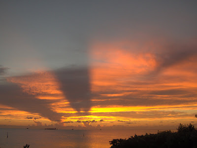

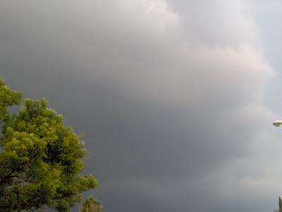
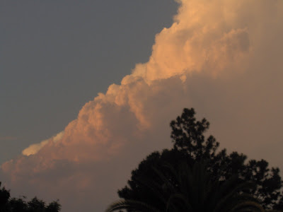

Keep your eyes to the sky.....JESS
A WEAK SURFACE LOW PRESSURE AREA AND A UPPER-LEVEL LOW NEAR THE
FLORIDA PENINSULA ARE PRODUCING A LARGE AREA OF DISTURBED
WEATHER OVER THE WESTERN ATLANTIC...NORTHERN BAHAMAS...AND THE
EAST COAST OF FLORIDA. THERE ARE NO SIGNS OF ORGANIZATION AT
THIS TIME. HOWEVER...SURFACE PRESSURES ARE SLOWLY FALLING AND
ENVIRONMENTAL CONDITIONS APPEAR FAVORABLE FOR A SUBTROPICAL OR A
TROPICAL CYCLONE TO FORM OVER THE NEXT DAY OR TWO...AS THE
DISTURBANCE MOVES WESTWARD OVER FLORIDA AND INTO THE GULF OF
MEXICO. REGARDLESS OF DEVELOPMENT...THIS SYSTEM WILL LIKELY
BRING SHOWERS...SQUALLS...AND LOCALLY HEAVY RAINS OVER PORTION
OF FLORIDA DURING THE NEXT DAY OR TWO. MOSAIC DOPPLER RADAR FROM
THE SE US SHOWS SCATTERED TO NUMEROUS SHOWERS WITH EMBEDDED
TSTMS ROTATING CYCLONICALLY MAINLY OVER NORTH-CENTRAL FLORIDA.
SCATTERED SHOWERS ARE ALONG SOUTH FLORIDA EAST COAST.
Wednesday, today Happy hump day its all down hill now.
The skies have been beautiful this week now i have a special interest 93l east of my state and its looks to go right over my area to find his strength in the gulf.
Weather is so complex, I think that's what i like about it so much .its like cooking you need just the right ingredients to make it all come together. the Low pressure is practically sitting right on top of my area and the tropical wave is off the east coast as the low pushes away it will bring the wave and once its in the gulf its anyone's ballgame. so will this be Tropical or sub tropical ether way it will be a learning lesson for me and fun to watch plus the cloud action should be amazing!
I chose some of my favorite pictures of the sky i took this week to share, i hope you enjoy.
Keep your eyes to the sky.....JESS
Friday, September 14, 2007
fighting to live/TS Ingrid
Well she made it, barely but she is now a storm. Will it become more? It really doesn't look like it with all the shearing that lies ahead check it out...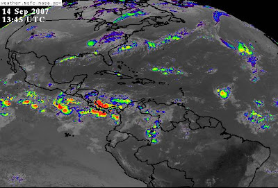
I will be keeping my eyes on it, but i don't hold any hope for her. Its a ruff sea out there right now.
In my neck of the woods it looks like another typical summer day again it looks like the west coast seabreeze will keep most storms off the coast(coastal drought) I think i need to move more inland...lol
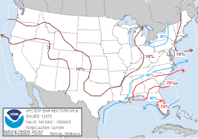
Last night i watch from a distance the clouds being lit up, by the time it reach me i was sound to sleep. .26" rain so i didn't miss much.
well i gotta go earn some dough, I will post if by any chance i can get out for an easterly chase today, my mom is coming over so chances are i will be stuck here:( but one never knows.....Happy Friday and remember KEEP THOSE EYES TO THE SKY!!!JESS

I will be keeping my eyes on it, but i don't hold any hope for her. Its a ruff sea out there right now.
In my neck of the woods it looks like another typical summer day again it looks like the west coast seabreeze will keep most storms off the coast(coastal drought) I think i need to move more inland...lol

Last night i watch from a distance the clouds being lit up, by the time it reach me i was sound to sleep. .26" rain so i didn't miss much.
well i gotta go earn some dough, I will post if by any chance i can get out for an easterly chase today, my mom is coming over so chances are i will be stuck here:( but one never knows.....Happy Friday and remember KEEP THOSE EYES TO THE SKY!!!JESS
Thursday, September 13, 2007
Current Tampa Nexrad Radar Map : Weather Underground
Current Tampa Nexrad Radar Map : Weather Underground
rain is coming of course its dark my camera stinks,anyway its bed time to oot i can bareley keep mys eyes open, i will post more in the morning
rain is coming of course its dark my camera stinks,anyway its bed time to oot i can bareley keep mys eyes open, i will post more in the morning
while you were sleeping
Last night before i went to bed i was watching the radars, I was looking at Humberto.
I was thinking to myself well that sure does look like a hurricane to me at that point it was still A TS. I wish i would have saved that picture to share, because now waking it has been moved up to A hurricane with wind at 85mph. As Dew said first one in two years.
Right now I'm learning about the Bermuda high, interesting feature it is, as sits in the atlantic in the summer it placement is like a shield to hurricanes, i'm still in the learning progress but it appears to me the main reason why Florida has not seen its share of tropical systems in the last couple years.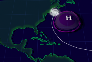
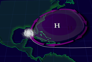
Now what i don't understand the bottom picture is the high in the '04/'05 how did we get storms as it looks like the high is wrapped around the state.
Like I said I'm still learning anybody out there that can add to my knowledge would greatly be appreciated!
Anyway TD9 doesnt seem to fairing well with the wind shearing and i read on Jeff's blog that is forecasted for the wind shear to get stronger in a couple of pics i have u can plainly see..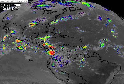
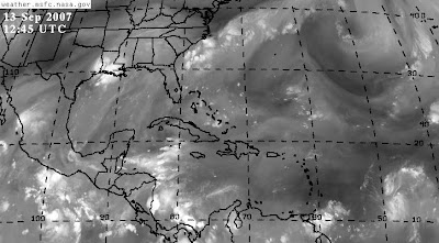
well i'm off to work..bummer i'd much rather sit here and watch the radars... but gotta pay those pesty bills.
Ta ta for now.....Jess
I was thinking to myself well that sure does look like a hurricane to me at that point it was still A TS. I wish i would have saved that picture to share, because now waking it has been moved up to A hurricane with wind at 85mph. As Dew said first one in two years.
Right now I'm learning about the Bermuda high, interesting feature it is, as sits in the atlantic in the summer it placement is like a shield to hurricanes, i'm still in the learning progress but it appears to me the main reason why Florida has not seen its share of tropical systems in the last couple years.


Now what i don't understand the bottom picture is the high in the '04/'05 how did we get storms as it looks like the high is wrapped around the state.
Like I said I'm still learning anybody out there that can add to my knowledge would greatly be appreciated!
Anyway TD9 doesnt seem to fairing well with the wind shearing and i read on Jeff's blog that is forecasted for the wind shear to get stronger in a couple of pics i have u can plainly see..


well i'm off to work..bummer i'd much rather sit here and watch the radars... but gotta pay those pesty bills.
Ta ta for now.....Jess
Wednesday, September 12, 2007
its not over yet/ were only half way there
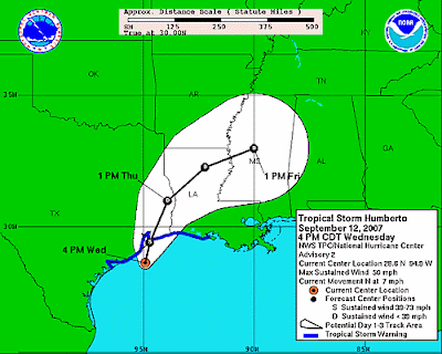
Wednesday, September 12, 2007
(From the Sert homepage)
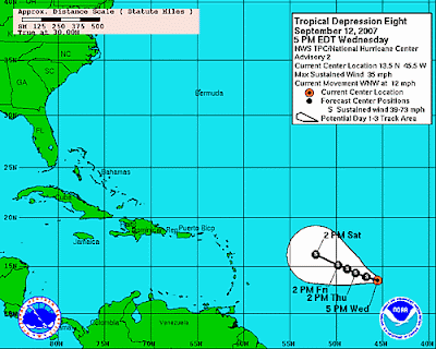
Tropical Storm Humberto Forecast to Make Landfall Along the Upper Texas Coast Overnight...Tropical Depression Eight May Become a Tropical Storm This Evening over the Central Atlantic...
Tropical Depression Nine in the northwestern Gulf of Mexico was upgraded to Tropical Storm Humberto earlier this afternoon.
The system developed along the tail end of a cold front just off the Texas coast. At 5 PM EDT, Tropical Storm Humberto was located about 50 miles south of Galveston, Texas. Maximum sustained winds had increased to near 50 mph, and the storm was moving slowly northward at 6 mph.
Tropical storm watches and warnings remain in effect for the upper Texas and southwestern Louisiana coasts. The official forecast from the National Hurricane Center takes Humberto ashore along the upper Texas coast overnight as a tropical storm, spreading heavy rainfall over southeastern Texas and southern Louisiana. Although no immediate impacts to Florida are expected, residual moisture from the remnants of Humberto may linger over the Gulf Coast region along a stalled frontal boundary and contribute to some much-needed rainfall over northwestern Florida into the weekend.I hope its a little more central west, we need rain here too.
Meanwhile an area of low pressure over the central Atlantic was upgraded to Tropical Depression Eight by the National Hurricane Center earlier this morning. At 5 PM EDT, TD #8 was located about 1065 miles east of the Lesser Antilles, or about 2450 miles southeast of Miami. Movement was toward the west-northwest at 12 mph. Maximum sustained winds remained near 35 mph.
The official forecast calls for the depression to gradually strengthen into Tropical Storm Ingrid later this evening or on Thursday. The system is forecast to continue on a west-northwesterly course over the next few days as it is steered by a ridge of high pressure over the central Atlantic.
An aircraft reconnaissance mission into the system is scheduled for late on Thursday. It is too early to speculate whether or not this system will pose a threat to the United States.
We can only hope....he he he I know it sounds sick but I want some action darn it!!!
Not a bad storm maybe just a cat 1 or 2, I'm not asking for carnage just something to watch and boy we sure could use the rain.
Speaking of rain its not gonna happen here tonight, looks like another beautiful sunset!! oh well heres looking to the weekend, Thursday is already upon us this, week has moved quick.
I'm gonna go play with my boy Ta Ta for now!
ALWAYS KEEPING MY EYES TO THE SKY....JESS
Saturday, September 8, 2007
felix gone but sub tropical Gaberial hangs close to Nc/Sc coast
Two days off in a row and no fun weather,I've been keeping an eye on sub tropical storm Gabriel, still disorganized but it will bring much needed rain to the east coast!! I'm getting a little nervous we are in our half way mark for the rainy season and we still our way below the normal mark, we really need to to see some rain over here on the west coast(central)Friday we received .25" Summer showers. I used o love those when i was a kid....Wait I still do!! Who doesn't like to play in the rain!!
I just hope we see more before the dry season returns.
I do have to admit I am looking forward to some cooler air, I love the change of seasons!!
This is from the SERT homepage:
The area of low pressure located between Bermuda and the southeastern U.S. coast continues to become better organized. Air Force Reserve Hurricane Hunter aircraft currently investigating the system have not yet found a well-defined closed center of circulation. However, upper level shearing winds have weakened over the past 24 hours, meaning that the environment surrounding the system has become more favorable for development. Thunderstorm activity has also become more concentrated since Thursday. The disturbance will likely become a tropical or subtropical cyclone within the next 12-24 hours as it meanders slowly westward or west-northwestward over the warm waters of the Gulf Stream. Due to its proximity to the coast, tropical storm watches could be issued as early as this evening. Forecast models usually do not handle weak tropical systems well, but current models show the disturbance continuing to drift west-northwestward toward the Carolina's and mid-Atlantic coast during the next 2-3 days.
At present, this system poses no threat to Florida; however, strong northeasterly winds along the west side of the disturbance will generate ocean swells that will lead to a high threat of rip currents this weekend along the southeast Florida coast beaches. Additionally, there will also be a moderate risk of rip currents along the panhandle and Big Bend coast on Friday. Beach goers should check with local lifeguards or beach patrol and heed any warning flags or signs.
Unsettled weather associated with a trough of low pressure will spread over south Florida this weekend. Rain chances will gradually increase on Saturday and especially into Sunday as the trough lifts northwestward, bringing an abundant supply of moisture to the southern peninsula. With deep tropical moisture in place, locally heavy rainfall will be a potential threat on Sunday across the region.
Meanwhile, high pressure over the southeastern U.S. should keep north Florida mostly dry through the upcoming weekend. Rain chances may increase slightly by Sunday, with a few coastal showers during the morning hours and mainly isolated showers and thunderstorms during the afternoon and evening. With moisture levels forecast to gradually increase by late in the weekend, rain chances should return to more seasonal levels by the first half of next week.
Temperatures this weekend will be in the upper 80s to low 90s along the coast, with middle 90s expected in inland locations. Drier air and lower humidity associated with northerly flow around the area of low pressure in the Atlantic are expected to keep heat indices around 100 degrees or lower across the northern tier of the state.
Elsewhere in the tropics, disorganized showers and thunderstorms associated with a trough of low pressure extend from southern Louisiana to Cuba. While upper-level winds across the Gulf of Mexico remain favorable, any development should be slow to occur.
AVILA SAYS
Issued at 530 AM EDT SAT SEP 8 2007
Atlantic Tropical Weather Outlook
000 ABNT20 KNHC 080907 TWOAT TROPICAL WEATHER OUTLOOK NWS TPC/NATIONAL HURRICANE CENTER MIAMI FL 530 AM EDT SAT SEP 8 2007 FOR THE NORTH ATLANTIC...CARIBBEAN SEA AND THE GULF OF MEXICO... THE NATIONAL HURRICANE CENTER IS ISSUING ADVISORIES ON SUBTROPICAL STORM GABRIELLE LOCATED ABOUT 315 MILES SOUTHEAST OF CAPE LOOKOUT NORTH CAROLINA. A TROPICAL WAVE LOCATED A FEW HUNDRED MILES SOUTHWEST OF THE CAPE VERDE ISLANDS IS PRODUCING A LARGE AREA OF CLOUDINESS AND THUNDERSTORMS. THIS SYSTEM HAS THE POTENTIAL FOR SOME DEVELOPMENT DURING THE NEXT FEW DAYS AS IT MOVES WESTWARD AT ABOUT 15 MPH. ELSEWHERE...TROPICAL CYCLONE FORMATION IS NOT EXPECTED DURING THE NEXT 48 HOURS. PUBLIC ADVISORIES ON SUBTROPICAL STORM GABRIELLE ARE ISSUED UNDER WMO HEADER WTNT32 KNHC AND UNDER AWIPS HEADER MIATCPAT2. FORECAST/ADVISORIES ON SUBTROPICAL STORM GABRIELLE ARE ISSUED UNDER WMO HEADER WTNT22 KNHC AND UNDER AWIPS HEADER MIATCMAT2. $$ FORECASTER AVILA
Well have a beautiful weekend and remember
KEEP YOUR EYES TO THE SKY!!!
Jessika Bland
Sunday, September 2, 2007
Felix update!!
Watching from a far...Nothing for me this weekend but Felix is ruling the tropics!!
UPDATE:Felix is now a cat 5 hurricane with @165mph presure dropped too 935 wow what an impressive storm!9/3/07
Sunday, September 2, 2007
Felix Strengthens into a Category 3 Hurricane while Passing to the North of Aruba...Felix Forecast to Impact Central America or the Yucatan Peninsula as a Category 4 Hurricane on Tuesday and Wednesday...Low Pressure Center off the Georgia Coast Moving Slowly Eastward...Heavy Downpours Possible in North and Central Florida on Sunday Afternoon and Evening...Tropical Wave in the Central Atlantic Ocean Remains Disorganized...
At 2 PM EDT Sunday, the eye of Category 3 Hurricane Felix was located about 100 miles to the northwest of Aruba, or about 1,170 miles to the east-southeast of Belize City, Belize. Maximum sustained winds have increased to near 125 mph, and Felix continues its brisk west-northwest pace around 18 mph. Tropical storm watches are in effect for Jamaica, but Felix is forecast to pass well to the south of Jamaica and the Caymans on Monday and Tuesday.
A ridge of high pressure is forecast to remain to the north of Felix during the next several days. This feature steer Felix on a west-northwesterly course through mid-week. The official forecast strengthens Felix into a Category 4 hurricane on Labor Day before the cyclone threatens Central America, Belize, or Mexico's Yucatan peninsula on Tuesday and Wednesday. Felix is not a threat to Florida during the next 5 days, but this hurricane may enter the southwestern Gulf of Mexico later this week after interacting with land. Please visit the National Hurricane Center for the latest information on Felix.
A low pressure center has developed off the Georgia coastline along a stalled frontal boundary that extends westward across north Florida. The low pressure center off the Georgia coastline may slowly develop into a tropical depression during the next few days it drifts eastward over the warm waters of the Gulf Stream. Weak steering currents could cause this system to move erratically off the southeastern U.S. coast.
The stalled frontal boundary will once again fuel the development of scattered thunderstorms across north and central Florida on Sunday afternoon and evening.
Elsewhere in the tropics, thunderstorm activity associated with a tropical wave located in the central Atlantic Ocean about 1,400 miles to the east of Barbados in the Windward Islands has not become any better organized today. Easterly wind shear and dry air aloft in the vicinity of this wave should prevent significant development during the next 24 hours. There is some potential for slow development later this week as this disturbance moves slowly westward through the central Atlantic Ocean.
Update: Felex is now a cat 4, go to Jeff gammon's site to checkout the latest updates!!you can find to right of my page also dewdrop is again doing a fantastic job with her forecast
Subscribe to:
Posts (Atom)